![]()
It’s hard to imagine any modern smartphone without a GPS service. Location data accuracy has become one of the top desired features for mobile apps our customers order today.
JFYI: the list of the iOS/Android apps 2015 tops with GPS-enabled apps. The amount of apps with utilized positioning service comes close to half a million for iOS/Android put together. Another fact is that child/teen tracking apps just claim momentum. So why not to make your app trendy?
While our customers design new GPS-assisted apps, development companies chase each other to offer the most accurate GPS apps.
So why GPS is a must-have feature for your app in order not to take the dust on AppStore and GooglePlay?
GPS: let’s turn the inside out
As a slight forewarn for that article: you won’t find a fundamental research on technical aspects of the GPS. Instead we’ll investigate the way it operates and share hacks how data accuracy can be improved.
GPS stands for Global Positioning System developed by the US government that became available for free usage in 1995 and first was used for the US military purposes.
It’s one of the rare government projects that you can definitely say we’ve gotten bang for our buck,
said Richard Easton, author of GPS Declassified: From Smart Bombs to Smartphones.
By diverse estimates it increases the US GDP by $100 million yearly! But well, here’s how it works in few words:
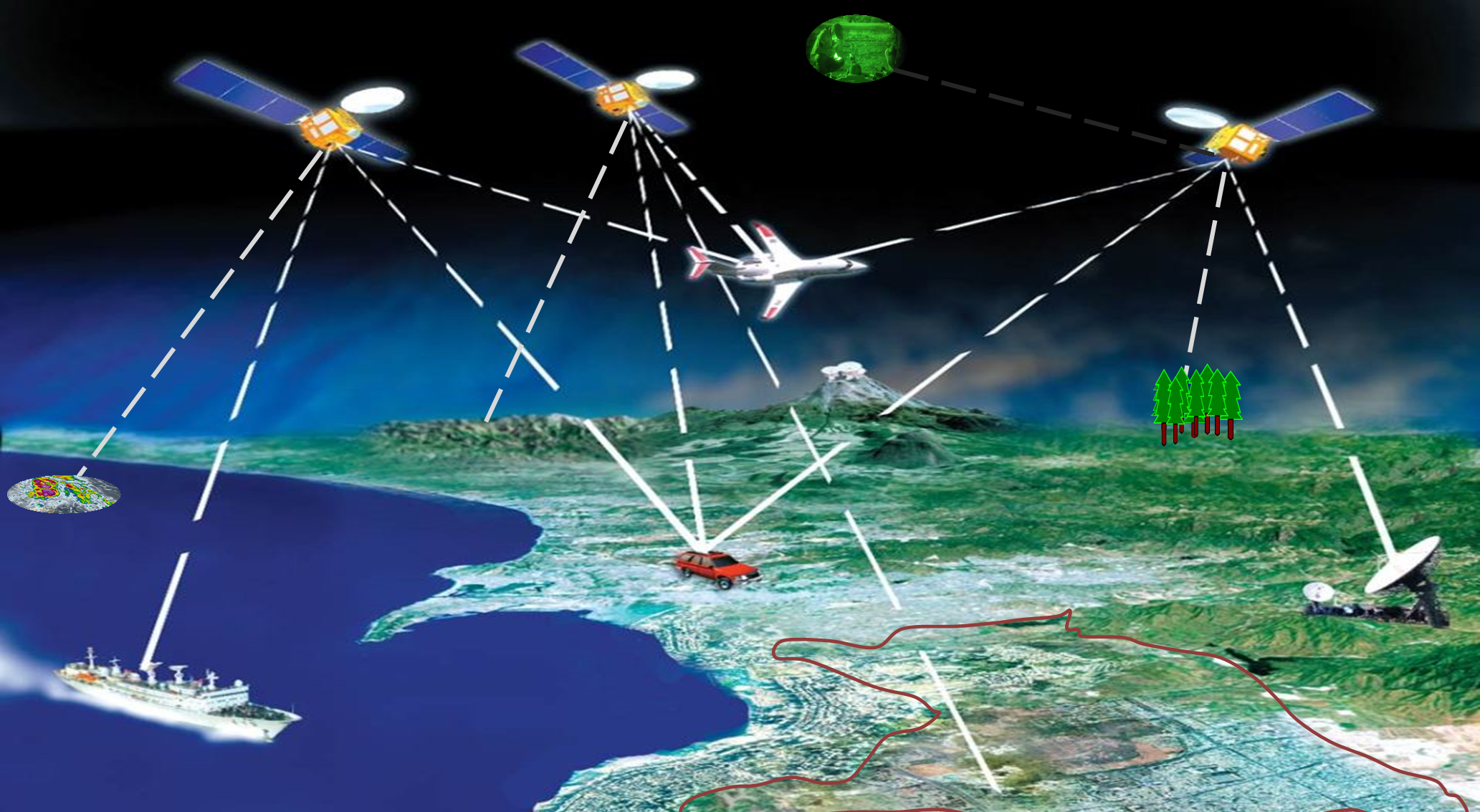
The GPS is a system of satellites owned by US government that provides positioning, navigation, and timing services for every device able to connect to them. There are currently 27 satellites that broadcast a time stamp on their current location and time the signal was produced with frequency of every 30 seconds.
To learn your location your GPS receiver needs to get signals from at least 3-4 satellites and calculate with approximacy of up to 10 meters the latitude, longitude, and elevation of your positioning according to the current time.
Any modern smartphone has a GPS receiver that accepts such messages and uses data to calculate the distance with speed of light info (radio signal) and time this signal was sent. Voila!
But that’s even not a half of it! GPS signal recognition and positioning are a tough challenge for smartphone, so here are 4 main ways your mobile identifies your location:
GPS
Initially smartphones could connect directly to satellites and calculate the distance to at least 3 of them to provide you with your location data. The data is transmitted via radio signals and such technology is most used now for vehicles, planes, boats etc. The accuracy of such data is low that’s why Assisted Global Positioning System was developed for smartphone usage.
It demands more time (at least 20 seconds to connect with satellites) and runs the battery down very fast. Not used nowadays.
A-GPS
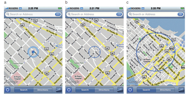
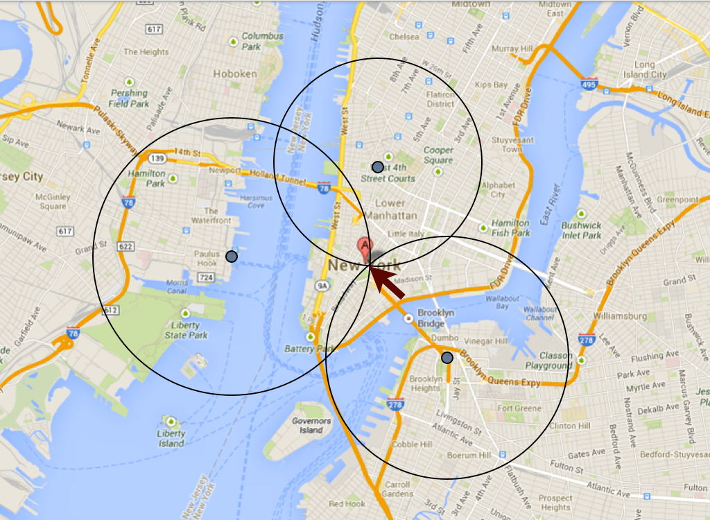
Accuracy of iPhone locations: a) Assisted GPS, b) WiFi and c) Cellular positioning
A-GPS performs the same as GPS, with principal difference that it gets the information not directly from satellites, but via additional resources like mobile area wires that are often called assistant servers. All modern smartphones have built-in A-GPS chips. Such technology demands less time to learn the location, saves the battery and gives the most accurate results.
WiFi
Since GPS accuracy directly depends on accessible and cloudless sky, WiFi is another resource for your smartphone to identify positioning. It operates with wireless APs to measure the intensity level of signals it performs and calculates the position.
Fancy that it doesn’t depend on whether your device is enabled to WiFi.
Cellular
That is the most inaccurate method of navigation. This way your smartphone provides you with location data based on triangulated location of the closest cellular towers. Most operators have detailed info on their towers’ locations that can give you approx. locations data to you since such towers can be located too far away from each other. This is more urban-oriented approach that works best in big cities with high concentration of towers and strong signal.
Both WiFi and Cellular approaches are used as an indoor methods of positioning. They won’t give you the highest accuracy, but able to assist your A-GPS data for the most precise location.
What affects accuracy?
For the other shoe to drop there are plenty of issues arising when it comes to accuracy. Concerning safety apps for children, teens and even pets that point is vital.
So, what prevents mobile GPS to show exact positioning of the object?
Let’s start over from the fact that most up-to-date navigation services can pinpoint your location with minimum fault of 3-10 meters, providing that you are located in the city, outdoors and have strong cellular connection.
But there are still some points you should always take to account if you need to get the most accurate data. What can cause inaccuracy?
GPS signals travel huge distance through the atmosphere from satellites to reach your mobile phone (in most cases they do it via special devices) and the quality of such signal plays major role. The problem is that your phone needs to get messages from at least 3-4 satellites at a time to provide you with location data. So for better signal you should at least be outdoors. This way your phone won’t meet any barriers on its way and your device will have an opportunity to choose the closest and strongest signal.
In addition urban canyons reduce the GPS signal accuracy since receiver is limited to connect the necessary amount of satellites at a time. In other words: the more sky view you have, the more accurate signal you get.
Among other reasons for poor data we can mention:
Failure to reach the necessary amount of satellites
Once your device failed to access at least 3-4 satellites – you won’t get precise location estimate.
Cold start
If you haven’t asked your GPS to locate you for a long time (or traveled far away without notifying it) and turn it on, you’ll need to give your device a couple of minutes (it can take up to 5) to come around. But if you often use sport apps for instance that frequently track your location, there won’t be any delays and fails.
Signal Blocks
You can’t even imagine how many barriers a signal meets on its way. Brick walls, high concrete buildings, trees, mountains and even human body! So when you keep your smartphone in a back poсket, in you bag or inside the car do not expect high accuracy. Give your phone a huge portion of a clear sky to catch the necessary info for you not to get lost.
Urban Running/Cycling
Those who prefer to track every single meter they walk/run/ride via mobile apps, should excuse their devices for another 3 meter’s location data precision. When you move fast your GPS has a “jumpy” signal from satellites so are the results. When riding a bike you do “zig” and “zag” and your device has to connect to different satellites to realise where you are. And then, concrete jungles are wrong place to get pure positioning.
Inappropriate hardware and software
The more innovative device you have – the more accurate data you get. For instance iPhone 4S and further 5, 5S etc support both GPS and GLONASS satellites data from Russian satellite system, so the quality and accuracy are evident.
What do you get on practice?
GPS is about precise figures, coordinates and exact time so any signal bounce, blocking or even slight disturbance result in significantly inaccurate data on your location.
How to increase accuracy?
So now you know that GPS is very dependent on various aspects and here are some tips and tricks that will allow you to get the most precise location data on a specific device.
- make sure your device has as high and airy position as possible to catch the GPS signal;
- avoid places like canyons (natural or city streets surrounded by skyscrapers), dense forests, spaces with stout walls etc;
- specific devices have different GPS chips, so if you know in advance that GPS is vital for you – do you best to make a research to buy an appropriate one;
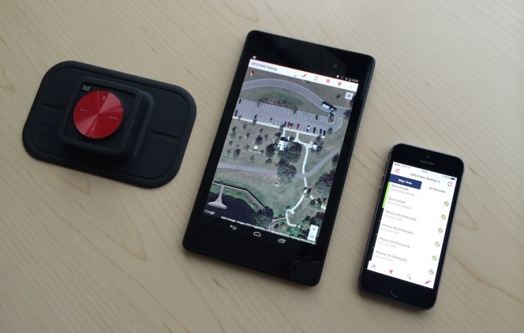
- connect a third party Bluetooth GPS receiver for better signal like “The Universal Bluetooth GPS Receiver” for example that is not costly, and will improve your positioning data notably.
And don’t get us wrong, but restarting your device or turning GPS on/off for several times helps more often than it may seem. Genius lies in simplicity.
Technology Reboot: GLONASS

Sounds familiar or do you hear this word for the first time? Just believe that if you have iPhone 4S for example (for the full list of devices go here), you already use it.
GLONASS (Global Navigation Satellite System) is the Russian version of GPS, that uses 27 satellites to give global coverage. In fact, it has no benefits over the US analogue, but ability to use both GPS and GLONASS satellite systems doubles accuracy of your location data. So that’s another prove and reason to buy an up-to-date device that supports both of them.
The future of GPS
Everyone wants to benefit from location awareness and business owners compete each other to satisfy the mobile app’s market with the most efficient and accurate solutions.
An open secret is that integration of GPS service can cost your users’ batteries suffer. Guys from PathSense promise to solve this trouble and provide a solution to cut the battery losses when using GPS by 90% and improve accuracy.
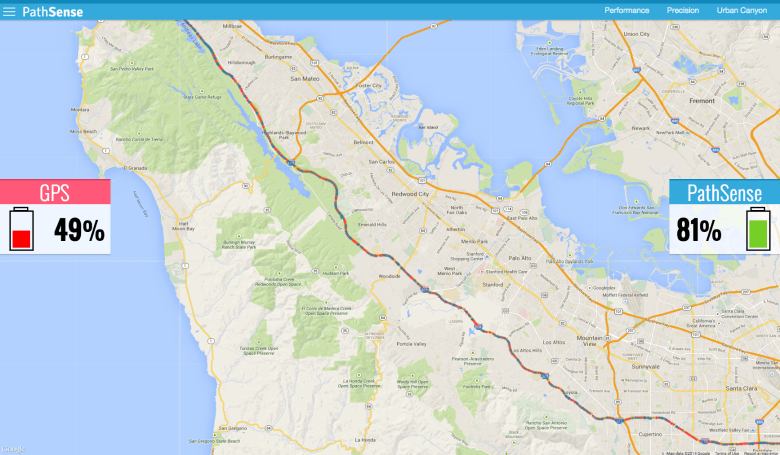 The idea is to involve your phone’s internal sensors like magnetic sensors, accelerometers and magnetometers to work in special algorithm to learn the location without GPS data. The app will track you only once when you launch and pinpoint your location saving your battery this way.
By working via PathSense server the app performs at no internet connection and sometimes even more accurate than time-honoured GPS.
In addition, the future GPS 2.0 will develop to improve the indoors navigation and soon your device will be able to navigate you through corridors and floors of huge buildings. Mostly via WiFi.
Together with PathSense, Skyhook and Geoloqi also discovered alternative ways of positioning. Skyhook for example combines WiFi, GPS, Cellular and IP address data that allow to quickly pinpoint you on the map. The service can be integrated into your app to allow easy monetization, in-app purchases or bringing social features.
Speaking about the importance of GPS integration it’s hard to omit advertising. New GPS features that would constantly track user’s location would allow to display them the most relevant ads according their position. So make sure to be the first to benefit from such feature.
Would like your app to become a flagship?
Remember, in order to be one step ahead of your competitors you need to monitor technology novations and stay updated on the latest GPS a pps released.
GPS is an acknowledged breakthrough in the world of location positioning. One can’t imagine his life with Instagram to share photos from holiday or Foursquare to decide where to dinner or find your way home at long last! Absolutely any mobile app can benefit from integrated tracking ability, both for corporate and private purposes.
Our team has deep understanding of appropriate GPS integration so you can trust your idea to be implemented by experts. Meanwhile have a look at our recent GPS solution implemented for yachting.